
A Summer Flight We Won’t Forget
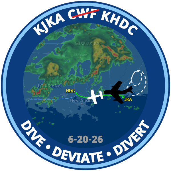
June 20, 2026 - by Charles Galles
We spent a week in Gulf Shores, Alabama for a family reunion. The weather was epic in all the bad ways. A tropical storm formed in south Texas and moved right through Louisiana and Mississippi. We had several days of rain or threatening clouds and the beaches were closed for 3 days for high wind and dangerous surf conditions. I managed to squeeze in one sightseeing flight along the coast in our club's Piper Arrow II, N121DB.
For several days before the return trip, I was reviewing forecast discussions and each day the same: a stubborn stationary trough across central Louisiana and Mississippi, feeding moisture northward and lurking just inland along the Gulf Coast. On the day of our departure I decided the best strategy was to stay south along the coast, get to Lake Charles (CWF), and then figure out the best way to angle north toward Dallas once we were past the worst of the mess.
That plan also gave us multiple outs with airports along the coast if the sky decided to change its mind. And with a day like this, we expected to be reassessing the route constantly.

Threading the Window
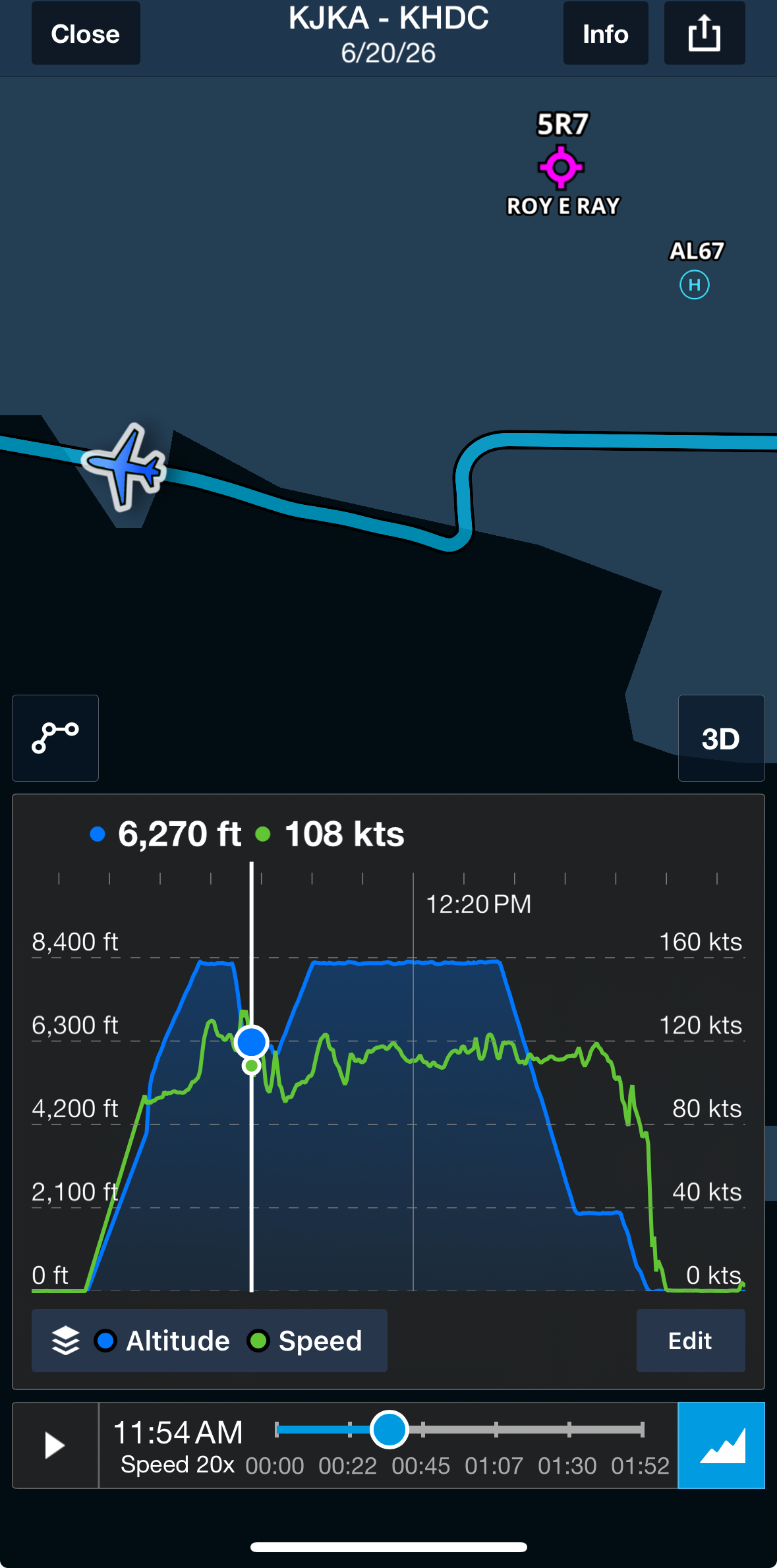
Morning IFR ceilings kept us from leaving early, and afternoon heating threatened to close the door later in the day so we chose to depart at 11:00. We launched from Gulf Shores (KJKA), turned west, and climbed to 8,000 feet toward Lake Charles (KCWF), about 2.5 hours ahead. I could already see buildups north of us, but our route looked okay to our south.
For the first half hour, everything was going pretty much according to plan.
Then Mobile Approach called.
“N121DB, turn twenty degrees left…”
The controller advised me of another aircraft same altitude to our right, type unknown. I started looking and then heard "N121DB, turn twenty degrees left". I immediately started that turn but before we even reached the new heading, the instructions escalated quickly:
- “121DB, left turn, heading 190.”
-
“Descend six thousand immediately.”
-
“Turn right heading two‑seven‑zero — now!”
I pulled power and rolled into a steep descending turn left and then right. Colleen, who had been peacefully reading her book, looked up with a very understandable "what on earth is happening?" expression. Once we leveled at 6,000, the controller explained the likely culprit: a MiG jet doing aerobatics over the bay, not talking to anyone.
Not exactly the Saturday traffic we expected. We didn't hear anything more about the MiG, so I'm going to say that our club's Piper Arrow successfully evaded a MiG jet. That's my story and I'm sticking to it! I wonder if I can get a MiG icon painted on N121DB ...
And a big thank you to the Mobile Approach controller for keeping us safe on our journey!
The Weather Tightens
Back on course, we climbed again and began weaving around buildups near Gulfport — no surprise there. It had large buildups on our inbound flight, and during the week we heard multiple aircraft being vectored around it. Must be something in the water there.
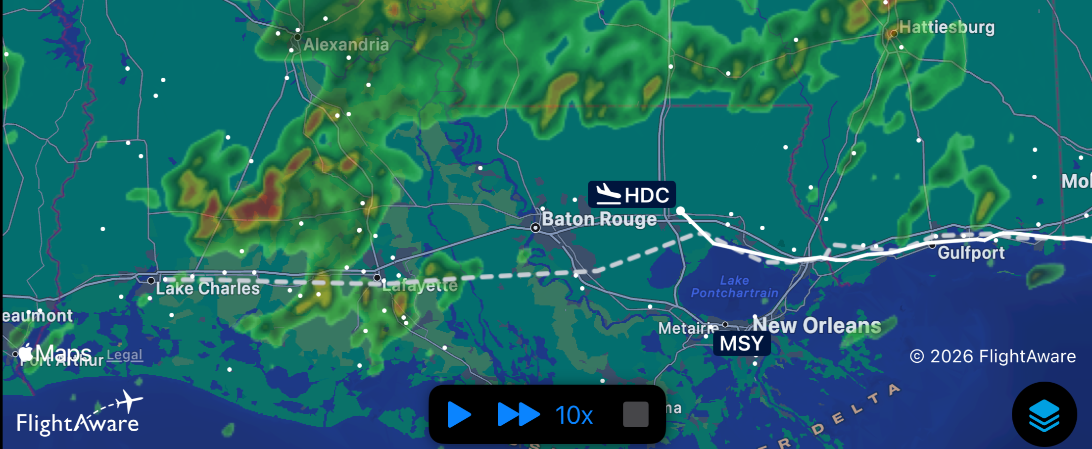
Meanwhile, ADS‑B showed new cells popping up near our destination, threatening to choke off our planned route. ATC eventually cleared us direct to Lafayette (LFT), which helped us steer clear of GPT, but the picture near Lake Charles and Baton Rouge was getting worse. It was starting to look like time for Plan B.
A Better Option: Hammond (KHDC)
During the flight planning I had checked out a few airports that would be along our route in case I needed to divert. Some didn't have fuel but a few of them had services and FBO's with good reviews. With the weather tightening, Hammond Northshore Regional (HDC) looked like the best place to divert and regroup. It was only twenty minutes away, and conditions there were workable: bases around 2,500 feet, six miles visibility, and a straightforward GPS 31 approach. I advised New Orleans approach of my intention to divert there and after picking up their ATIS I was cleared direct to the COBIM initial approach fix for the RNAV 31 approach.
We landed, taxied off the runway, and discovered the “Terminal” building was locked — but a friendly flight‑school pilot pointed us toward Pierce Aviation. The FBO staff welcomed us in, offered drinks, snacks, and even a crew car if we needed it. Southern hospitality at its finest.
Watching the Atmosphere Shift
On the ground, I started looking at the trends and radar returns. The east‑west wall of precipitation was sliding along the north side of Lake Pontchartrain just to our south but not pushing northward. In fact, the activity north of us was weakening, and a gap was opening to the west.
A walk outside confirmed the picture: dark clouds to the west, lighter skies to the north, and only light to moderate rain to our north. Lightning was distant and stayed mostly south of us. The atmosphere was giving us a narrow but usable window.
We filed a new route via ICEKI and then direct to TKI, pre-flighted, and got ready to launch again — fully expecting to keep evaluating the sky the entire way home.
A One‑Hour Pause That Made All the Difference
In just under an hour, the storm line had slid east, leaving us on the quiet side of the weather — almost like ducking under a breaking wave and watching it roll past. The diversion wasn’t just prudent; it was the reason we were able to complete the trip home. All things considered, this was probably the most eventful and challenging flight I have ever done. However, I felt calm and confident knowing that I had done my research, preserved my options, and had ATC as a helpful resource to conduct the flight safely.
Takeaways
- Weather planning takes time. A cross-country trip requires researching trends and forecasts at multiple sites.
- Kudos to ATC. Their quick vectors kept us clear of an unexpected aerobatic visitor.
- Diverting is a solid tool. Sometimes it’s the smartest, calmest move you can make.
- Research the route. Check the reviews of airports along the route. Some have facilities and some don't.
- Stay flexible. Even with a solid plan, the Gulf Coast weather can keep you on your toes.
Opportunities for Improvement:
- Study the airport diagram before you land - I could have gone right to the FBO at HDC if I had pulled up the plate and studied that better during my approach briefing.
- Bring tiedown straps - fortunately the winds never got too strong during our diversion, but I was really wishing I had gone to hangar 250 and picked up a set of tiedowns for the trip
- Really watch that automatic gear override on the Arrow. It is easy to forget when you are maneuvering or climbing. It's a nice system but definitely review the system.